https://gcn.gsfc.nasa.gov/gcn3/32744.gcn3 ("GRB221009A: Detection as sudden ionospheric disturbances (SID)")
https://www.qsl.net/df3lp/grb221009/KLM_grb221009a_magnitude... (from the above link)
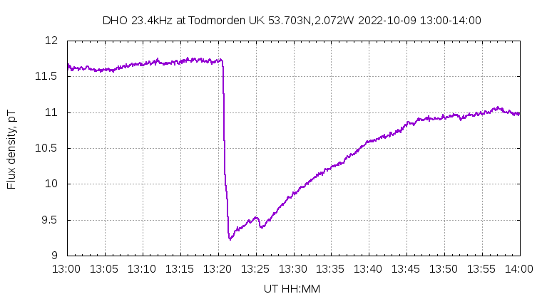
http://abelian.org/vlf/grb221009a-DHO.png
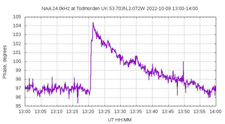
http://abelian.org/vlf/grb221009a-NAA.png
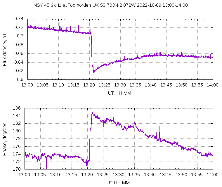
http://abelian.org/vlf/grb221009a-NSY.png
[0] https://news.ycombinator.com/item?id=33215572 ("Record-breaking gamma-ray burst possibly most powerful explosion ever recorded")
This was detected with VLF radio, but I wonder if this kind of event also has an effect on GPS signals? The time-of-arrival of astrophysical gamma rays isn't uniform across the earth.
Active support and collaboration came from Pakistan, Iran and Libya who were all trying to develop nuclear weapons of their own.
https://rusi.org/explore-our-research/publications/commentar...
https://www.google.com/search?client=firefox-b-d&q=aq+khan+p...
https://en.wikipedia.org/wiki/Abdul_Qadeer_Khan
Yes there was a great deal of outside help with their enrichment and weapons design.
They don't need outside help.
These distortions are not constant. They change from time to time. There are many different ways to account for them. One of the most accurate solution is to keep a GPS receiver on a well known location. Since you know that this receiver haven’t moved you can use the signal measured to estimate the parameters of the ionosphere between that station and the satelite.
Normally these signals are used to correct GPS navigational solutions. You take the closest station to your moving receiver and assume that whatever way the ionosphere was distorting for that station will do the same for your receiver too. This is valuable so there are network of such GPS stations in a lot of places.
Here they use the data collected by these stations differently. Instead of correcting a navigational solution they visualise the measured state of the ionosphere as seen by a bunch of these stations.
A simple GPS receiver will have a generic mathematical model for the ionosphere and use that as a good guess. More advanced ones can measure the delay directly.
The ionosphere affects different frequencies differently, so the GPS satellites transmits additional signals at different frequencies. By measuring the phase of these signals (L1 and L2), the math can be done to get a better estimation of the delay caused by the ionosphere between each satellite and the receiver. Those are the dots we're seeing on this animation. (GPS also uses the L2 signal to transmit encrypted information that lets military receivers get a better fix than civilian receivers).
more info: https://www.e-education.psu.edu/geog862/node/1715
I wonder if a network of connected devices with a GPS-disciplined SDR receiver and a regular GPS one could work both as this project does plus as passive radar like the software that was recently taken down. The purpose would be to have much wider coverage along with redundancy and error correction.
GPS being a military technology, I presume those fixed gps stations are only located in US-friendly countries. You wouldn't get that adjustment if you are flying over Russia or China, or any ocean. How much of an error in absolute distance are we talking about here? A few cm or meters or a km?
GPS receivers work by figuring out how far away they are from a number (>3) of GPS satellites. The receiver knows where the GPS satellites are (since the satellites broadcast their orbit parameters) so if a receiver knows how far it is from several satellites it can work out where it is itself.
Now, as the GPS satellite signals travel through Earth's atmosphere, they can be slowed down by different atmospheric effects. A slower signal will cause the receiver to think it's farther away from a satellite than it really is, so the receiver might estimate that it's position has changed a little bit. However, if you know the receiver's position hasn't change (maybe it's fixed in place to a big rock), then you can attribute the receiver's measured "change in position" to a change in atmosphere characteristics.
In this paper, they seem to have lots of fixed GPS receivers all over the place. By looking at all of them together, they can make a sort of map of the atmosphere characters in a part of the sky that's affected by rocket launches. The authors see these big ripples emanating from a Falcon Heavy launch in the US and this tweet shows those same ripples emanating from a launch site in North Korea.
For made up simplified example, assume you have a moving GPS in an airplane or something, and there's exactly four sats N S W E. All four sats relatively agree you're flying the plane normally in a straight ish line as usual. Suddenly, the data from the S sat gets wildly distorted, but the other three sats remain normal. I suppose the S sat could have malfunctioned but more likely something is in between your plane and the S sat. So your navigation chip tosses the data from the S sat and marks its SNR way down and generally ignores that sat... However, if you were to log that "bad" data from the sat to the south... then compare to someone flying a plane a hundred miles to your south, and their GPS reports data suddenly was trash to their north, then you know something flew between your two planes. Maybe an ICBM, maybe a thunderstorm, maybe a GPS jammer weapon, a lot of "it depends". Sometimes its the data thats tossed out thats the most interesting.
I've been fooling around with something a LOT cruder at home WRT tracking thunderstorms. Its not rocket surgery to know that severe rain attenuation can impair GPS signals. One of the standard NMEA output lines contains each sats SNR, so if I know from my "vast" database that in normal weather satellite #43 at az 45 degrees elevation 45 degrees reports a SNR of made up number -10 plus or minus 2 over the past few years, then if it reports -20 today that would imply either the sat just burned out (unlikely) or there's a rain cloud causing "about 10 dB attenuation" at az 45 degrees elevation 45 degrees relative to my house. The linked project in the article is enormously fancier of course than merely logging SNR fluctuations.
I'm amused at the idea of crowdsourcing a "large amount" of forest hiking data over time to evaluate the health of the tree canopy in forests. Where I live the leaves are all down now so GPS signals should be very strong for hikers in forests.
As the Air Force discovered decades ago, for various EE and trigonometry reasons, bistatic radar works best overhead its kind of the opposite of what you want for an early warning radar so you can see why bistatic radar never went much of anywhere compared to traditional radar for the usual Air Force mission purposes. Although there are interesting modern "IoT" distributed sensor applications, at least if you have unimpeded fast communications systems, etc.
Some fun house mirrors are flexible so they can get pushed or pulled which will make you look taller or shorter or fatter or skinnier than you know you are.
By observing the difference between how you appear compared with how you are; you can learn something about how the flexible mirror is being curved.
How this works in the fun house is there is you the mirror and LIGHT.
Both you and the light are well known and easy to predict; light will travel straight(ish) and you will not suddenly become very very short, so the thing that is changing your appearance is the flexible mirror.
In the GPS rocket case, the GPS satellites are the illuminating source corresponding to the light in the room sending out radio (electromagnetic radiation same as light just at longer wavelengths)
The ground station GPS receivers correspond to your eyes (they know what they *should* see).
The earth's ionosphere corresponds to the flexible fun house mirror.
taken together, the same way you could tell if something we can't see behind the mirror flexed it, the author of the post showed they can tell if, when and where an unannounced rocket goes through the ionosphere.
You use GPS receivers to detect ionospheric disturbances. Ionosphere, coming from the word "ionized", means it consists of charged particles, positive or negative. (Missile) exhaust is mainly neutral molecules, creating a "hole". These ionospheric holes can be detected through the Faraday Effect[2]. By measuring the Faraday rotation of radio signals (like GPS), you can detect these holes. I think this is similar to how polarized light 3d cinema systems work, except it's the radio spectrum instead of light.
[1] https://agupubs.onlinelibrary.wiley.com/doi/full/10.1029/201...
You can figure out if someone moved a brick (or launched a missile) because your voice changes when it reaches your friend and he needs to apply a new change to get your voice back.
We can see the signal changes the rocket causes to the ionosphere and know that it's happened.
Yeah, we had a detector with some ML stuff, it worked okay, but the main issue is there isn't much training data.
Overall the false positives are quite low (visually, which is hand wavey, of course). I've not really seen a big event that was not real. I ran it for a while 24/7 and while there are "scintillations" there aren't any circular waves. False negatives are a much bigger issue. Something like an IRBM or SRBM doesn't really show up, and those are much more common.
Fwiw, this uses a bandpass filter to look for the ripples, which filters out a ton of noise. Looking at ionospheric depletion would be good and probably more sensitive, but it requires accurate models of what the ionosphere ought to do. I've tried a few things there with mixed results.
Where can I read more about the meta level concept of "isopheric disturbances"? (Because I suspect I'll find this has been done by military intelligence for a long time then rediscovered by so called "arms control" wonks who insist on putting their code into the public domain.)
https://agupubs.onlinelibrary.wiley.com/doi/full/10.1029/201...
> who insist on putting their code into the public domain
You say that as if there is something wrong with that.
So to be clear, you an arms control expert public domaining code that aids totalitarians like Putin and the North Koreans has... "nothing wrong with that"?
Some domain specific knowledge was meant to be esoteric* and there are a variety of better licenses such as CC-non-commercial that allow peaceful uses of the code without allowing it to be used by literally anyone on the planet.
(*Unless you pay the proper fees, of course. But that's not just about money... you have to earn the right to make the purchase.)
======== It is widely recognized that rocket launches can be an anthropogenic source to trigger traveling ionospheric disturbances (TIDs) by generating acoustic-gravity waves (Afraimovich et al., 2002; Arendt, 1971; Bowling et al., 2013; Calais & Minster, 1996; Chou et al., 2018; Ding et al., 2014; Kakinami et al., 2013; Li et al., 1994; Lin et al., 2014; Lin, Chen, et al., 2017; Lin, Shen, et al., 2017; Noble, 1990). The rocket-induced long-distance propagating TIDs associated with shock/ducted gravity waves and internal gravity waves were observed by using Arecibo incoherent scatter radar (Noble, 1990) and ground-based Global Positioning System total electron content (TEC) observations (Calais & Minster, 1996). Lin, Shen, et al. (2017) first reported the rocket-induced shock waves and concentric TIDs (CTIDs) subsequently using Global Positioning System TEC over California-Pacific region. They suggested that the CTIDs are the manifestation of concentric gravity waves that were originated from the mesopause region. ====
The effect seems to be proven quite a while ago. Using GPS receivers to make that widely accessible seems to be new, but I honestly doubt that military intelligence would rely on that - I’m confident they have more direct methods to detect launches such as (radar) satellites.